Wind tugging at my sleeve
feet sinking into the sand
I stand at the edge where earth touches ocean
where the two overlap
a gentle coming together
at other times and places a violent clash.
Across the border in Mexico
stark silhouette of houses gutted by waves,
cliffs crumbling into the sea,
silver waves marbled with spume
gashing a hole under the border fence.
—Gloria Anzaldúa, Borderlands/La Frontera, 1987
In 2017, as Hurricanes Irma, Maria, and Jose swept through the Caribbean, the northern border bridge connecting Haiti to the Dominican Republic was swept away by the rain-swollen Massacre River below. Photos of the concrete bridge that had been torn down and washed away by the water circulated on social media, signifying for many an interrupted flow of commerce, people, and politics: the environmental disaster had literally ripped away the infrastructure of the state border. Thirty kilometers downstream of the fallen bridge where the river border meets the ocean, the rain-swollen river also made an appearance in Monte Cristi—where I was conducting ethnographic research. Fishermen were marooned on land as the fresh water from the river carried silt, mud, and trash into the ocean, changing the color of the sea from blue to brown. Despite the extraordinary environmental conditions that had made it possible, the photograph of the broken border bridge seemed oddly familiar to me. Looking toward the shores of Haiti, the photograph of the hurricane damage was a stark reminder that the borders of the nation were made not of concrete, and not of land, but of water. In my seven years of conducting research in the border region of the Dominican Republic attempting to capture the stories of border communities, I ended up with a photographic portfolio of how water dictated the political, social, or physical entanglements that could occur at the boundary of the nation.
This photo essay—a product of those images—takes aim at the border, one of anthropology’s central sites for understanding the production of difference (Rosaldo 1989). In the midst of tempestuous politics of difference across the globe, this essay illustrates the sets of practices (Paasi 1999) and the social field (Bourdieu 1993)—in this case an aqueous one—that exist despite trends to solidify difference. The photos included here feature rivers, floods, and the sea as a conduit for leisure and trade, saturating expressions of community, commerce, and play. Borderwaters—the concept I put forward through this series of images—are both places and actors, sites where border politics and daily life unfold. Attention to these borderwaters allows us to hear and engage with voices from a much broader environmental body, one that is rapidly changing. Human entanglements with the environment on and off of Hispaniola impact how borderwaters converse with this region, where everything from river runoff to intensifying hurricane seasons shape the way water engages and is engaged in border worlds. These images seek to imagine water as more than just the context for social and political life. Water is in conversation with the other actors in the border, be they state officials or residents of the region. Given that my ethnographic awareness of borderwaters grew from the way water “talked back” at me through photos from my fieldwork, the invitation of this photo essay is to ask how water speaks through its presence in various forms to negotiate and correct ways of imagining and organizing social and political life. My aim is to forefront conversation as a practice embodied in borderwater worlds, a practice that also emerges through photography as ethnographic analysis.
The often-pejorative language used to refer to border crossers such as mojado, wet-feet, and boat people suggests that water has a place both in the politics and the experience of borderscapes. Scholars have discussed how seascapes serve as places of legal and political limbo (Perera 2007), as well as how floods and tides serve as metaphors for border anxieties (Chavez 2001). Epeli Hau'ofa (1998) suggests that water, rather than land, should serve as the mooring for regional identities, a stark challenge to the pervasive logic of the territorial nation-state and one reiterated in the history of Caribbean relations (Bassi 2017). To simply say, “borders are fluid,” too easily leans on water for its value in metaphor without exploring how different material experiences produce distinct social, economic, and political motions (Helmreich 2011; Steinberg and Peters 2015). Thinking deeply about water’s play in lives at the periphery of the nation-state suggests that water speaks to different dimensions of borders. This photo essay illuminates lives lived in conversation with bodies of water too often made to stand in silently as the “natural borders” of the nation-state.
Those who keep company with the fluid border here are the first to note that fluidity is neither exclusively gentle nor predictable. From riverbeds to expansive tributaries, stream crisscrossed valleys to mangrove lagoons, and out into two oceans, the border between the Dominican Republic and Haiti is rarely dry. Fluidity as a material form at the border has facilitated political revolutions and transgressive imagined communities (Martí 2002; Bassi 2017), but water has also played a part in historical and contemporary frictions. The Massacre River along the northern stretch of the border owes its name to the violence of nation building along its shores (Turits 2002). Chemical and solid waste has detrimental consequences for people and fisheries downstream. Floods claim the lives of those whose social and economic status forces them to reside on low, vulnerable lands. Mangrove estuaries hide the violence of the drug trade that passes through this island, en route to North America. And ships sink when they hit unexpected reefs or shoals in the seascape of this border region. For the protagonists of the images below, these characteristics of fluidity provide the context for their engagements with borderwaters.
This photo essay follows the currents of border rivers north out into the Atlantic, and in doing so, it also follows my own path as an ethnographer in this region. My research sites migrated north with the river water and evolving projects, flowing out into the ocean. While water is now central to my ethnographic work in this border region, this was not always the case. The photographs I took at first were snapshots meant to set the scene of fieldwork and interviews, or methodological exercises in portraying the relationships between border colors and textures through black and white images (Images 3 and 7). Yet whenever I returned from the field to comb through this data, I found that water figured in every frame, regardless of whether my research circled the portrayal of cholera at border crossing sites (Images 5 and 7), transnational social organizations (Images 2, 3, 4, and 5), or the health of fishing communities (Images 9, 10, 11, 12, and 13). Photography, I found, was a space of conversation between the unexpected actors in a field. This essay moves from these first unintentional images of borderwaters to the moment when I realized water’s presence, engaging with it deliberately (Images 1, 11, 12, and 13). The later images in this essay trace how I began to engage more consciously in the conversation with borderwaters and their accomplices. Photography was one of the few methods available when I decided to conduct ethnography underwater in the border region, and it provided a means of exploring the sensorial aspects of borderwaters. Diving into borderwaters meant that my methods had to contend with magnified issues of mobility, perspective, and communication. Attuning my photographic eye often meant simultaneously attuning my senses to an environment that engaged differently with light, gravity, and color.
The images I present in this photo essay span places, projects, and perspectives collected through seven years of ethnographic work in the region. My own engagements with border residents and border environments have taken various forms including consultant, activist, friend, and novice spear fisher. For the purpose of this essay, however, I have chosen to depict the interactions and engagements between Dominicans, Haitians, and the water between them, rather than exploring how my interlocutors chose to engage with me and with the presence of a camera. The work of an ethnographer entails a considerable amount of trailing people around, and as such, many of the photographs are taken from this perspective. Despite this, the protagonists of these images were all aware of my presence and that of my camera.1 Since these images stem from various ethnographic projects that take place in Dominican border communities, I cannot claim that this photo essay equally portrays the experiences of Dominicans and Haitians with borderwaters. What it does offer, however, is a glimpse of social and cultural tides from Dominican shores, expanding the dimensions of what we imagine when we think of lives lived entangled with boundaries.
Notes
1. All names are pseudonyms, with the exception of Osiris Blanc, who passed away in 2017. His name is used with his previous permission.

Download “Borderwaters: Conversing with Fluidity at the Dominican Border” by Kyrstin Mallon Andrews as a pdf booklet.
Photos
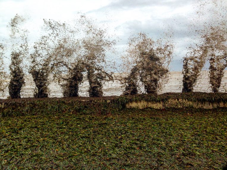
Image 1. In 2007, the Dominican Republic announced itself an archipelagic nation. Declaration 66-07 extended the nation’s reach to “submerged territory” including reefs, atolls, offshore islands, and the aquatic spaces between them. This law declared political borders shared not only with Haiti, co-inhabitant of the island, but also with Turks and Caicos to the north, the United States to the east (via Puerto Rico), and Colombia and Venezuela to the south. Through this law, the state formalized and codified national boundaries that sit primarily on the surface of the sea. By shifting the national discourse from “island” to “archipelago,” the seascape is made into a zone of patrol, and border concerns are brought to bear on an aqueous territory.
The devastating hurricanes of 2017 tore through these imagined borderwaters. Dominicans watched as Puerto Rico, Turks and Caicos, and the Bahamas were pounded by wind, waves, and rain, bracing for the impact of a weather system headed their way. The boundary between land and sea, reinforced in Monte Cristi by the seawall pictured here, did little to stop the violent swells coming into the bay. Lobster, eels, fish, and mountains of sea grass were sloshed to land by mud-heavy swells, reminders that aqueous territories have their own rules of engagement.

Image 2. Chickens, rubber boots, used clothes, and bags of rice lined the path down to the border on market day in Bánica. We walked down the road that hugged the riverbank, momentarily out of the market clamor, glancing sideways at two border patrol guards lounging in plastic chairs. Abel, my guide here, raised a hand to them in greeting, and we continued down to where the road disappeared under the milky waters of the border river.
Twice a week markets occur on both banks of the Artibonite River, where men in dugout canoes transport market goers between the Dominican Republic and Haiti for a small fee. These dugout canoes, an indigenous technology, precede the very notion of the nation or colony on this island. Those who navigate the border here are not members of the border patrol. Rather, they are the men with mental maps of the river’s contours and the embodied knowledge of how to move across water. While political whims and tensions spark increased militarization or heavy press coverage of the border from the Dominican side, the Artibonite has a logic of its own, canceling market days with heavy rains and flooding, or facilitating trade in the dry season when one can wade across the border.
We step off the canoe onto the Haitian bank, and walk up the steep enclave where Abel greets a Haitian vendor, “Cousin!” He insists that we sample the local clairin, a less refined, raw rum popular in Haiti, and one of the main draws to the market this side of the river.

Image 3. The coffee farmer doesn’t pick up her phone. In the mountains south of Dajabón, the northernmost border crossing, swollen rivers crisscross roads through the region. Hoping to talk to a woman who lives deep in this network of waterways, two border residents and I stop to ask a man for a forecast of the roads. Dark but sparse clouds are the evidence from rains earlier this week. Rains in Haiti may mean flooding in the Dominican Republic, and vice versa, and our path to Rio Limpio where we hope to speak with one small-scale coffee farmer and her family may be blocked as rivers and streams jump roads and gutters. Like the flooding they forecast, the hearsay of the border region moves through the landscape with the flows of people and the voices they carry. Knowing which routes are possible or which towns are inaccessible depends on the flow of conversations carried through the region. We won’t be able to reach the woman today, despite the height of our vehicle, and we leave the conversation for a drier day.
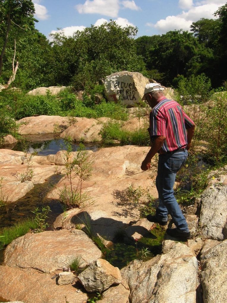
Image 4. A self-made ecologist, Osiris Blanc is known for his family’s long-reaching roots in the frontier region of Loma de Cabrera. He pointed to groves of bamboo, explaining how he personally planted them along the banks of the river, holding the loose dirt and runoff out of the bi-national watershed. We moved through the town on foot, following liquid waste, “aguas negras,” from the hospital, mechanic shops, and latrines, to the river. Blanc’s home sat above the riverbank. “People usually have their patios facing the street, and their bathrooms in the back, closest to the river. I designed this house differently so that my patio faces the river,” Blanc swept an arm toward the water below, “my life is oriented toward the river, my house should be too.”
Like the amalgamation of liquids that flow from the town into the waterway, connecting regions across borders, Blanc is an amalgamation of a shared Haitian and Dominican history. His last name comes from the western half of the island, and his family is well known for its role in the foundation of this town. Blanc’s father was said to be a galipote, or animal shapeshifter, an embodiment of fluid form in the borderlands.

Image 5. The calm water of the bend in the river reflected the local hangout spot. Bachata—the musical soundscape of Dominican daily life—boomed deafeningly across the river, but the sound waves left no trace on the water. Young Dominican boys flexed their blooming masculinity, performing acrobatic leaps off of cliffs into the deeper pools. The family of a border resident and I came here to escape the oppressive heat of Dajabón in the summer. In contrast to Dajabón’s Massacre River, this mountainous tributary is kept cool by spring water and shade. The water here flows into the Massacre, returning to Dajabón as we do, to contend with the heat and pollution downstream.
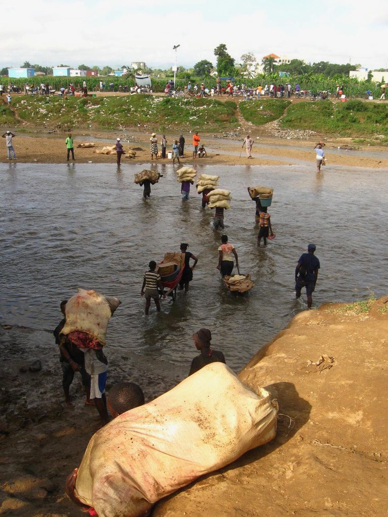
Image 6. At the northernmost border-crossing site, Dajabón and Ouanaminthe, those who cannot afford to cross the official border bridge with passports, visas, or bribes venture a quarter mile north, where Dominican border patrol agents loosely patrol an informal crossing point. Closest to the meat and poultry section of the massive bi-national market, many Haitian vendors buy in bulk on the Dominican side, crossing back to sell smaller portions in Haiti. The bank is steep and often muddy from constant foot traffic on market days. Soldiers, who are rarely long-term residents of the border, vocally hassle the occasional Haitian, more concerned with the opinion of their peers than the permeability of the nation.
Just south of here, the state has its concrete bridge, but border residents enact a different kind of bridge, a social and economic one that does more than cross the water. The flow of people who walk knee-deep in the border water highlights the way state borders reinforce socioeconomic hierarchies, boundaries. Crossing the water is a daily practice that insists on relations between people despite state dreams of division.
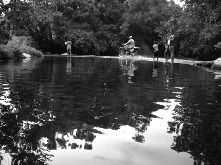
Image 7. Mountain roads dip down into valleys along the international highway, a road constructed sparingly between Haiti and the Dominican Republic in the 1930s. Rivers and streams may or may not flow, depending on the season and the rains at higher altitudes. Women walk across the road, wading ankle-deep in the freshwater, to visit neighbors or the local grocery store. Occasional motorcycles and cars run ripples through the calm pool where the road and river merge. Behind me, a father and son bathe in a deeper part of the pool, diving underwater and holding their breath for as long as possible before breaking the surface in laughter.
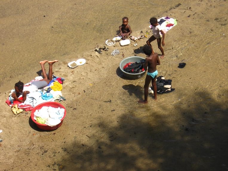
Image 8. Women and children inhabit the shallow Massacre River, washing clothes and eating food purchased at the bi-national market above them. The river’s name commemorates multiple occasions of conflict and bloodshed along the border, the most recollected being the infamous Parsley Massacre of 1937. By dictatorial decry, Haitians living on Dominican territory were targeted and killed by state forces, who could only identify them as Haitian after hearing them pronounce the word perejil, a series of letters that revealed French and Kreyol speakers from their Spanish cohabitants of the border region. Despite such bloody attempts to tear apart the seams of social life in this region, Haitians and Dominicans continue to mix their families, friends, and traditions.
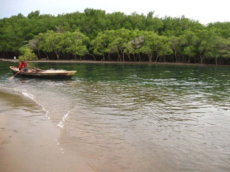
Image 9. Following the Massacre River less than thirty kilometers north, the border river lets out into the Pepillo Salcedo lagoon, where many residents fish for a living. Fresh water fish are more valuable than many salt water species, and lagoon fishing practiced with nets and sometimes poison can be traced back to Hispaniola’s indigenous Taíno residents. A Haitian fisherman sat at the crossroads of two nations and two waterways, floating between the Dominican Republic and Haiti, at the place where the lagoon opens up into the Atlantic Ocean. Nets of a smaller mesh were recently banned in the Dominican Republic, but this fisherman and others floated in the legally murky spaces just offshore of the nation. Fishing regulations are difficult to enforce in an environment where those best equipped to navigate are fishermen themselves, and where those charged with law enforcement are entangled in extralegal agreements with local businesses.

Image 10. A local dive instructor jumped off an abandoned ship, passing the time as he waited for his clients to arrive. The border bay, the deepest natural port in the northern Dominican Republic, hosts notable dive spots, the first a sunken cargo ship, confiscated after its involvement in drug smuggling and sunk as an artificial reef, and the second a deep wall of sponges just on the other side of the cartographic border line as it extends into the sea.
In this informal port, larger boats prepare to journey across a different water border to the Bahamas, where fishermen clandestinely fish for three-day periods, returning with commerce now scarce in Hispaniola’s depleted waters. Built in the 1940s as an export hub for bananas by the United States–owned Granada Company, Manzanillo has a ghostly feel, long abandoned by the American business. The streets are quiet, without the movement, laughter, and human encounter of most Dominican towns, no matter their size. More than land, the ocean here houses most activity, with ships disembarking for ports in the United States, and other boats heading for the Bahamas or Haiti, pirating goods and people through waters saturated by a history of illicit trade (Bassi 2017).
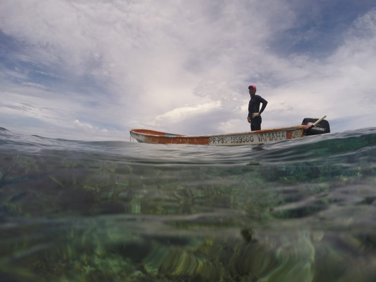
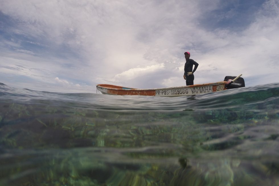
Image 11. North of Dajabón and facing the Atlantic, Monte Cristi depends on small-scale commercial fishing. Skilled divers and spear fishers, residents motor out to banks and reefs offshore, using the color of the water to measure visibility, depth, and location at a glance. Fresh water from the border rivers flows into the ocean, making certain fishing spots opaque and changing the temperature of the currents. Facing harmful river runoff and depleted marine reserves, fishermen increasingly cross the Hispaniola Basin to the north, venturing into Turks and Caicos where the water is always clear and sea life abounds. Fishermen like Luis, pictured here, regularly descend below the surface, moving through an often-overlooked dimension of borders: the subaquatic. Here, he stands watch over his colleagues as they work, making sure each of them safely crosses back to the surface from the depths of the seafloor.
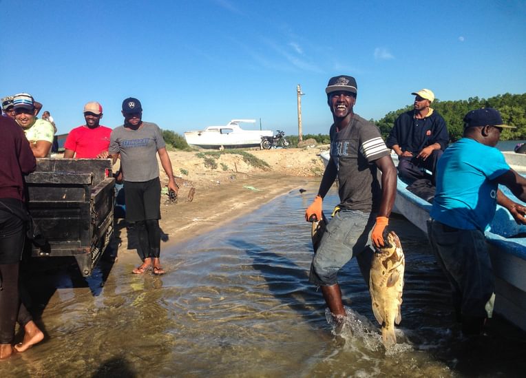
Image 12. “It’s my source of adrenaline,” the fishmonger remarks as he sits on the shores of the fishermen’s wharf, waiting for his boats to come into port after their 35-hour and 160-mile trips across the straight between the Dominican Republic and Turks and Caicos. Diver fishermen motor across the deep channel in outboard-motored boats, fishing clandestinely with air compressors in another nation’s waters. The risks of such a trip are financial for this fish monger and others, but the stakes are even higher for the divers who make up the crew. “We go there with two options,” one fisherman explained, “either we fish, or we get arrested.”
A crowd gathers at the bridge over the wharf, where family and friends of the fishermen await the arrival of the crew. Some wait for gifts of fish, promised to them in advance by crew members, or owed to them as payments of debts. The crowd ripples with anticipation as the wake of the boat becomes visible on the horizon. Everyone leans over the rail of the bridge as the boat comes in, the fishermen cheering with their arms raised in celebration as they float into port.
Helping hands and fish shop employees pull the boat up onto the sand, unloading the catch onto scales and into truck beds. The success of the voyage across borderwaters is reflected on the faces of everyone in the wharf.
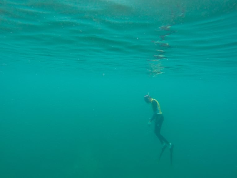
Image 13. The seafloor disappeared underneath a dense veil of dirty green water. Carlos appeared from the depths, floating back up into my field of vision from the invisible rock piling below. The Navy had prohibited fishing vessels from disembarking—ostensibly because of a weather warning, but rumors of smuggling collaborations circulated—forcing diver fishermen to navigate the waters they could swim to from the shore. Today, this water was dirty. I struggled to navigate my own body, spearfishing alongside Carlos, who knew every rock on the seafloor without seeing them. “Once, I killed twenty pounds of grouper right here!” He told me on the other side of the surface as he floated in opaque waters. While the ethnographer’s camera can only see so far into murky water, fishermen use other ways of sensing borderwaters to move through opacity, including hearing, touch, and embodied memory.
References
Bassi, Ernesto. 2017. An Aqueous Territory: Sailor Geographies and New Granada’s Transimperial Greater Caribbean World. Durham: Duke University Press.
Bourdieu, Pierre. 1993. The Field of Cultural Production: Essays on Art and Literature. Cambridge: Polity Press.
Chavez, Leo R. 2001. Covering Immigration: Popular Images and the Politics of the Nation. Berkeley: University of California Press.
Hau'ofa, Epeli. 1998. “The Ocean in Us.” Contemporary Pacific 10, no. 2: 392–410.
Helmreich, Stefan. 2011. “Nature/Culture/Seawater.” American Anthropologist 113, no. 1: 132–44.
Martí, José. 2002. “War Diaries.” In José Martí: Selected Writings, edited and translated by Esther Allen, 350–415. New York: Penguin Books.
Paasi, Anssi. 1999. “Boundaries as Social Practice and Discourse: The Finnish–Russian Border.” Regional Studies33, no. 7: 669–80.
Perera, Suvendrini. 2007. “A Pacific Zone? (In)Security, Sovereignty, and Stories of the Pacific Borderscape.” In Borderscapes: Hidden Geographies and Politics at Territory’s Edge, edited by Prem Kumar Rajaram and Carl Grundy-Warr, 201–230. Minneapolis: University of Minnesota Press.
Rosaldo, Renato. 1989. Culture and Truth: The Remaking of Social Analysis. Boston: Beacon Press.
Steinberg, Philip, and Kimberley Peters. 2015. “Wet Ontologies, Fluid Spaces: Giving Depth to Volume through Oceanic Thinking.” Environment and Planning D 33, no. 2: 247–64.
Turits, Richard Lee. 2002. “A World Destroyed, A Nation Imposed: The 1937 Haitian Massacre in the Dominican Republic.” Hispanic American Historical Review 82, no. 3: 589–636.